
|
|
Vermont Underwater Preserve |
 |
||||
| Wreck image indicates available sidescan image |
Location click link for chart |
Lat Lon |
Depth FFW | Comments | |
Phoenix 
| north face of Colchester Shoal | 44 33.3' 73 20.1' | 60 to 110 | 146' x 27' 1814 sidewheel steamer, sunk 1819 burned to the waterline, only hull remains | |
Horse Powered Ferry
 | Burlington Bay - 1100 meters NW of north point of breakwater | 44 29.1' 73 14.6' | 45 | 63' x 23', very fragile wreck, only known example of horse driven (turntable) ferry | |
OJ Walker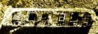 | Burlington Bay | 44 28.7' 73 14.4' | 60 | mostly intact Sensitive site registration please | |
General Butler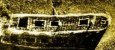 | Burlington Harbor breakwater - south edge, west side | 44 28.3' 73 13.7' | 40 | 88' x 14' 1862 sailing canal boat - sunk 1876, mostly intact | |
Coal Barge | north of Proctor Shoal (off Shelburne Pt) | 44 27.2' 73 14.7' | 60 to 80 | 90' x 14' 1800's canal barge, presumed to be the A.R. Noyes. Silty bottom | |
| Stone Boat | southeast of Diamond Island | 44 14.1 73 20.0' | 12 to 23 | 93' x 14'. Canal boat carrying quarried stone. Currents may be strong. | |
| Water Witch | 1000 ft south of Diamond Island | 44 13.93' 73 20.13' | 90 | 83' x 18'. Steamboat converted to sail. Built 1832 sank April 26 1866 while carrying iron ore. Currents may be strong. Sensitive site registration please | |
New York Underwater Preserve |
|||||
| Champlain II | Westport - n of Rock Harbor | 44 12.36' 73 22.58' | 15 to 35 | 258' x 35' 1868 sidewheel steamer originally named the Oakes Ames - renamed 1874 - ran aground 1875. Approx 160 ft of the hull remains, mostly debris | |